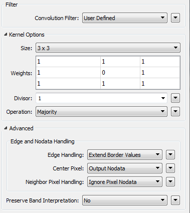
I've got some continuous rectangles(polygons), each of them represents an atrribute value from 1 to 5. So after symbolization they just look like a raster. Some of the rectangles have abnormal values such as 1 rectangle has value 1 surrounded by 8 rectangles have value 5. I'd like to change 1 into 5 in order to clean the data. Due to the polygons are rectangles not squares, I can't convert them into raster to perform a Majority Filter operation in ArcGIS.
Is there a way to perform same operation on vectors? I'm thinking about creating a list to store surrounded rectangles' value, then use ListHistogrammer to get most frequence value if they appear equal or more than half, then change centre value in it. I've tried to put data through SpatialRelator's requestor and candidate port to create the list, but I can't ignore the centre rectangle which creates 9 listelements.
I'm struck here, if you have any suggestions or a better/more efficient method, please help me, I'm all ears, thank you.
@takashi @david_r @Mark2AtSafe @DaveAtSafe