span8
span4
span8
span4
Recently at Safe we had an internal event where the FME Experts had the opportunity to spend a couple of days away from their normal jobs, and build whatever they like with FME. We named this event ‘Demo Daze’, and you can find out what we got up to in this blog post.
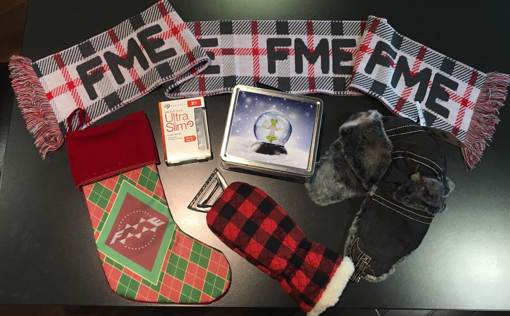
So, inspired by Demo Daze, we decided to extend the opportunity to our FME community, for the chance to win a one-of-a-kind, holiday inspired, FME prize pack.
There will also be reputation points and a Knowledge Center badge up for grabs - 100 points for the winner and 20 points for each contestant.
We’re giving FME users 12 days to work on and submit a project and share it with the rest of the community. Perhaps you’ll build something holiday inspired, give the 2018 beta a whirl or put that home licence to good use!
a) A title.
b) A brief description. For example, explain why you chose this project, what it does, and how FME was used to create the project.
c) A file containing your project demo or result. This could include a video, image, FME Hub submission, or workspace.
This question will be closed at 12pm PST Tuesday 12th December, where the answers will be available to vote on but submissions will no longer be allowed.
The winner will be the submission that has the most votes at on Monday Dec 18th at 12:00pm PST.
VOTES ON ANSWERS BEFORE THE VOTING PERIOD WILL NOT COUNT
(Please don’t vote until then, as they will be removed)
I love this idea, but at this moment I don't have the time to participate.
Maybe next year.
Inspiration for this project was: https://www.3ders.org/articles/20161220-3d-printed-gingerbread-house-lets-you-celebrate-christmas-the-scandinavian-way.html
2. Look at the result in Sketcup
3. Get a single house:
4. Explode the house into individual parts:
5. Workspace with description
6. End result - one PDF per part - and the simple PDF
7. Rent a bakery and print all the roughly 40 000 000 + parts to all the 2 770 000+ houses in Norway (TODO)
TODO if enough interest:
- Bake the house
- Rotate the geoemetries to "flat surface" by using the SurfaceNormalCalculator and 3DAffiner to get correct geometries.
TITLE:
Predicting football results using FME. Reducing hours of analysis down to 10 seconds.
BRIEF DESCRIPTION:
There are hundreds of football games taking place across Europe each weekend. To determine the best matches to place a wager can be very difficult. Using open data (upcoming fixtures compared with historical form) I am using FME to quickly analyse the matches that are best to bet on each game week. What used to take hours to analyse is now being achieved using an FME workspace that takes under 10 seconds to run. I have it set up on FME Server to send me (and my friends!) an email each time there are new decent bets available. It also now tweets from a new dedicated account @deadcerts.
I'm sharing the workspace here, and hopefully I will get some feedback and improvements from other tied up with FME and Football as their main work/hoby! If you make any improvements, which I'm sure you will, then maybe we can collaborate on a Github project? You can contact me @pinpointalerts
A title.
Executing a Workspace by phone call
A brief description.
Imagine your customer needs to Geocode so many addresses, but he would like to run your workspace from a phone call.
These Addresses are in Excel format in repository BOX and so many peoples are working in this Excel file.
Suddenly your client is not in the company and needs to run the flow and receive by email the results.
For this just call a phone number and the FME Server will start the process for you.
What you need is a Twilio Account ( www.twilio.com ), FME Server ( to schedule the workspace ) , a BOX account ( www.box.com ).
A file containing your project demo or result:
A title.
Server log saver and timeline visualizer
A brief description.
We have more and more schedules and I was less and less enthusiast to go through long-long list of logs (instead of building a snowman army for example now ☃☃☃) when someone didn't like something
Half a year ago I opted not to care with a few SLAs and build something visual (no, I cannot build nice tings) that save me some boring time ⛄.
I end up with this.
The workspace saves the Server log to a staging table (on request) for future reference. No cleanup now, the size of the table is the discretion whoever cares with it.
The timeline control is Google Charts (sorry anyone from China). It is not my dream as a timeline (no control over individual colours, no navigation, etc) but I just couldn't find anything decent. Until I hack one (that would look as nice as FME Server Schedules Dashboard inspiration) I chose a quick win solution temporarily.
Santa's trip around the world!
This Workbench connect to the API of Openstreet Map.
- It queries all the Christmas related features of OSM input by users like me!
- It creates a path between all the trees
- It creates a Web page to display the result using Leaflet
Title: FME Santa Nose based Air Quality Index for Chennai, India
Description:
If you ever thought that Santa Claus was old fashioned and not tech savvy?
You got it wrong, at least this Christmas season and not atleast the FME powered Santa Claus.
With the nose as his IoT device (real time air quality sensor) doubling up as an indicator, this FME Santa Claus is all geared up to indicate in real time, if it is safe to wander around the city this Christmas season.
SaintGIS has been helping FME Santa learn a bit of FME to perform a trick or two this season, ever since the FME hackathon was announced.
FME Santa has learnt:
1. To consume real-time air quality data from the federal government open data portal web services api in xml format
2. Source: https://data.gov.in/resources/real-time-air-quality-index-various-locations
3. Filter the data for places of interest he will be visiting.
4. Flatten the xml and generate real time reports on air quality
Well these html reports are unique to FME Santa, for it has his magical touch.
Yes, the reports for a key location ( https://goo.gl/maps/jEX7YvijHjG2 ) in the city of Chennai, India; not only contain real time tabular data on the prominent pollutants but also a colour changing image of FME Santa to graphically indicate the real time air quality of that place.
FME Santa's own nose and beard are the IoT sensors and displays.
They change colours to display the air quality in real time.
Very nice of FME Santa to have lent his nose for a noble social and environmental cause.
FME Santa wants to add a word for improvement that the html report can be made dynamic by scheduling the workspace using FME Server.
Attached is the FME Workbench template, a sample output html report and the screen grab of the html report
iot-fme-santa-sensornose-srg.fmwt
santaclaus-iot-nosesensor-realtimeairqualityindex.htm
Workspace that generates the lyrics for the song and uses the system speech synthesizer to "sing" it out on your loudspeaker. A guaranteed hit at the family dinner!
Workspace: 12daysofxmas.fmw
Output: 12 day of xmas.mp3 (Dropbox link, the forum didn't like my mp3)
Requirements:
If you don't want to install anything and just want to play around, simply disable the PythonCaller at the end.
Ho ho ho and happy holidays!
Title: Create map with index
Description: The ‘IndexMap’ Transformer was developed to automate the process of producing a map with an associated Index. This workspace work with points, lines and polygon features and can be used in any hemisphere in the world - NE, NW, SE, SW.
There are two links on the FME HUB
![]() Canada (Vancouver Parks) | Associated Index |
Australia (Canberra Roads) | Associated Index |
Output to Google Earth |
Regards
Greg Patterson
A title.
Spatial Search and Clipping on Terrain Model Stored in DB
A brief description.
This is a part of a big project whose goal is to develop a database system to store a bunch of 3D datasets including terrain surface models, BIMs, and point clouds. Regarding terrain models, the major requirements are:
A file containing my project demo.
The attachment contains two workspaces and a sample data, which demonstrate how FME works to handle terrain models according to the requirements. The workspace "load.fmw" loads the sample data to a SpatialLite database, and the workspace "extract.fmw" performs spatial search and clipping. Firstly run the "load.fmw" to create the SpatiaLite database before running "extract.fmw".
load-and-extract-terrain-surface.zip (created with FME 2017.1.1.1)
Left: Sample Data, Right: Spatial Search and Clipping Result
Title:
The VertexAngleCalculator custom Transformer
Brief description:
A Transformer that, given an Area or Line feature, calculates the directional change at each vertex. Output is available as both a measure on the original feature, or as seperate vertices containing the angles as attributes.
A file containing your project demo or result:
An entry on the FME Hub.
I love doing these kinds of calculations on geometry, and I had already researched the required steps once before. Seems rude not to try it in FME and to share it with others. I originally needed the angles to determine whether a polygon was clockwise or counterclockwise.
Since I can't compete with a puppy, here's a typical Dutch winter scenery of enthousiastic folk going to work:
© 2018 Safe Software Inc | Legal