Question

Can FME convert Ground coordinates to UTM?

  • 12 February 2020
  • 4 replies
  • 21 views

Badge

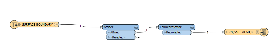
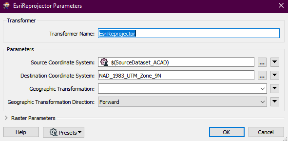
I have an AutoCAD drawing in ground coordinates and need to get this into a usable projection to use in ArcGIS Pro. Is FME able to do this? I have the math that is typically used to do such a conversion (below), but I am not quite clear how to implement this in an FME workspace:


To Transform Ground to UTM Coordinates

Example: Point100 (Ground) 13262.582 m N, 4380.119 m E

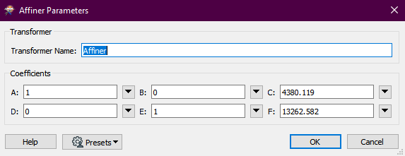
1. Shift back to the original scaled coordinate value:

13262.582 m + 6,000,000 m = 6013262.582 m N


4380.119 m + 410,000m = 414380.119 m E

2. Scale Point 100 from the Ground down to the Grid using the CSF:

6013262.582 m * 0.9996899303 = 6011398.051 m


414380.119 m * 0.9996899303 = 414251.632 m


Suggestions?

Thank you.


4 replies

Badge +2

@prpa_gis Affiner tranformer or a combination of the Offsetter and Scaler should do the trick. Then the CoordinateSystemSetter to set the coordinate system.

Badge

@prpa_gis Affiner tranformer or a combination of the Offsetter and Scaler should do the trick. Then the CoordinateSystemSetter to set the coordinate system.

Thanks Mark:

I will give this a try. This is exactly the software one would think would be perfect for this type of transformation, and this tool would be great if I can get it to work. Now I have a project :-). I'm assuming that it's going to be something like Reader ->Affiner transformer->projector->writer?

Badge

Naturally I'm having all sorts of problems with this. What my brain interprets as "intuitive" and what FME is asking me to do are obviously two different things :-).

This is what I have managed to create...all I'm trying to do is get something (anything) to transform, and once I have achieved that I can make the FMW more elaborate:

I get a fatal error starting with "Cannot write a non-area feature to an area feature class". However, I was trying to select and set the conversion to using a linear layer and output to a line type, but I continue to get the similar error messages.

I did get it to run without errors once, but there was no output at all.

My Affiner looks like:


My Reprojector looks like this (I thought setting the source coordinate system to the source ACAD file was a safe bet, but perhaps not?


In any case, I'm obviously missing something, but I'm just spinning my wheels here at the moment.

Suggestions?

Userlevel 2
Badge +17

Hi @prpa_gis,

To implement the transformation you described, please use an Offsetter, then a Scaler, in order to retain the order of operation.

Set the X offset to 410000 and the Y offset to 6000000.

Set both the X and Y scale to 0.9996899303.

Next, use a CoordinateSystemSetter transformer to set the coordinate system to the applicable UTM zone and datum (ie. UTM84-10N).

Reply