
It would be nice if the PointOnLineOverlayer could include Elevation (Z) and Measures (M) coordinates for multiple overlaps when Generate on Point to a List is selected as the output. Currently, it only returns Z and M for the first route in the list of multiple overlaps. Then the logic you've build to choose the correct route/segment would have every element including M & Z stored together in a single List Element.
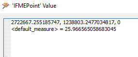
My Example has multiple routes/segments returned:

But only a single measure is available for processing:
It would be nice if the coordinate information could be included in the output List if user needed it.
The workaround: you can preserve the point & line geometries as an encoded geometry on an attribute (using GeometryExtractor) or as X/Y/Z/M using a combination of the CoordinateExtractor & MeasureExtractor. This would add your geometries to your list for either the Point output or the Line output.
Thought of suggesting using a MeasureExtractor and ElevationExtractor first, but I realize you want the elevations and measures from the line. A worthy enhancement request to be sure.